12 Must-Visit Spots In Donegal, Ireland
Donegal is a place truly cut of its own mold. Part of the Republic of Ireland, it sports the island's most northern point (even as Northern Ireland sits geographically above most of the rest of the landmass). Donegal is also home to what can only be described as an "individual" Irish accent. The people here are some of the nicest you'll meet anywhere in the country, but they can certainly be difficult to understand. Donegal is one of just three Ulster counties to have become a part of the Republic of Ireland upon its founding as the Irish Free State in 1922, and Donegal natives are fiercely Irish. Donegal has routinely been a county that exhibits significant numbers of Irish speakers and supports the largest geographical Gaeltacht (an area where people speak Irish predominantly) in the country.
The county is truly chock full of phenomenal destinations that visitors should prioritize. Atop Ireland's Wild Atlantic Way, Donegal looks physically perhaps more like a slice of Norway than the rolling hills and serene forests that dominate the rest of the island. The west and north of Ireland are characterized by the ocean that has pounded up against its shores and the result is a place, history, and people that are equal parts fascinating and enchantingly welcoming. I live in Ireland, and have been up to Donegal and the north many times. These destinations are therefore personal recommendations as well as those from friends, including some from this northern treasure itself.
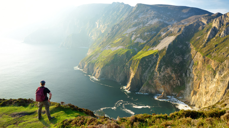
Sliabh Liag (Slieve League) Cliffs
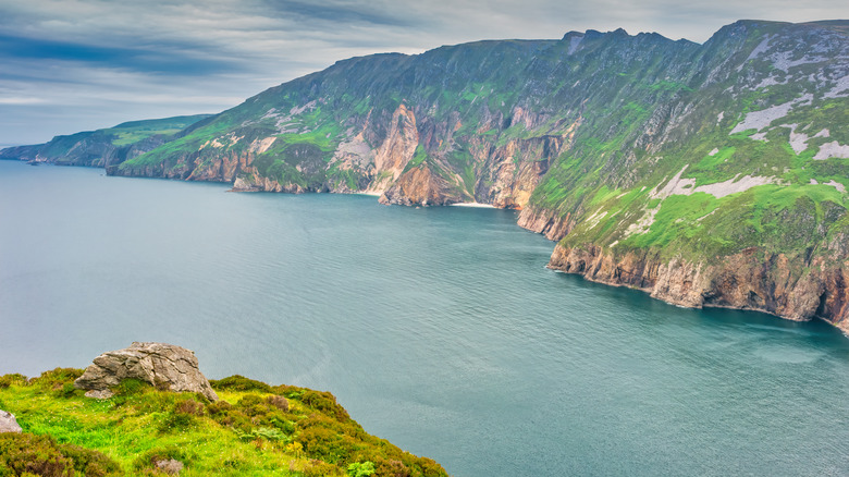
The cliffs along Ireland's west coast are truly magnificent. Perhaps non are as spectacular as those found in Donegal, however. The Sliabh Liag (Slieve League) cliffs are a majestic example of the furious power that the Atlantic Ocean has exerted on Ireland's exposed western edge for millennia. Visitors to the cliffs will delight in one of Europe's highest cliff faces, and the tallest on the island of Ireland. The tops reach almost 2,000 feet above the ocean wash below. As with Giant's Causeway just a short distance into Northern Ireland, Sliabh Liag is not only a fascinating sight but one that's intimately linked to the island's mythology, specifically that of Finn MacCool.
The walk up to the cliffs themselves involves quite the hike across rolling hills, but the journey is well worth the effort. For those visiting after an already lengthy day of travel, catching the buses that run from the visitor center down to the primary viewing point can make the voyage a bit easier. Regardless of how you arrive at the cliff edge, the choice to marvel at the waters below or continue the climb to see the geological treasure from even greater heights offers two equally stunning visuals.
Malin Head
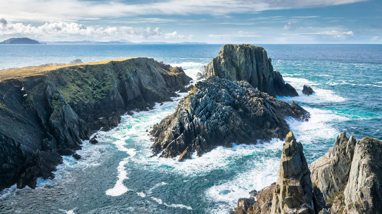
The northernmost point on the island of Ireland is found in Donegal, not the otherwise aptly named country of Northern Ireland. The county swoops around the western portion of the island's uppermost extent, and the landscape jutting out at its farthest northern reach is Malin Head. The wild rock formations and potent ocean remain in effect here, even as the eastern drift of the North Atlantic loses steam with the northern protrusion (rather than at the battered Mizen Head signal station down south in Cork that points out directly into the spray).
Malin Head is the terminus of a grueling bike trail that sees riders travel from Ireland's extreme south up to this northern point. As a result, anyone driving along Ireland's country roads to arrive at this sightseeing destination should take extra care and look out for platoons of bikers. In addition to its status as a grand achievement and the visually stunning views that await anyone exploring this part of the island, you'll find one of the WWII-era "Eire" signs just down the rocky shoreline from Malin Head's signal station. This one is "Eire 80" and has been pretty well preserved since its installation in the early 1940s. It's one of a network of signs built to alert Allied pilots that they were flying over Irish territory during the war.
Arranmore Island
Arranmore Island (Árainn Mhór) is home to one of Ireland's Gaeltacht areas — places where people speak Irish in daily life — and makes for an amazingly authentic visit. It's also a wonderful place to go for a few pints while you're traveling around Ireland. Pubs across the country pride themselves on their ability to pull a pristine pint of Guinness, and trad pubs like Early's Bar make for a great place to have a drink and soak in the music and environment of traditional Irish heritage.
Arranmore has been settled since ancient times, with a fort at Uilinn standing resolutely on one of the island's clifftops since around 800 BC. Beyond sightseeing and a unique experience of Irish culture, Arranmore Island is a fantastic place for fishing, scuba diving, sailing, and virtually any other aquatic activity you might try. Plenty of hiking trails open up the island to adventurous souls looking to explore the land, as well. Only about an hour from Donegal town, and Letterkenny, respectively, to the Arranmore ferry in Burtonport, this is a great addition to a trip through the north.
An Grianan of Aileach
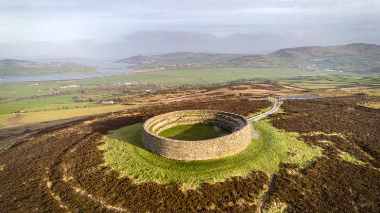
The Grianán of Aileach is a hilltop fort, built of stone and situated some 820 feet above sea level. It's near Burt, in the narrow corridor that connects northern Donegal with the lower portion of the Irish county. To its east is the border with Northern Ireland and Derry, just across on the other side. To the west is a great gash in the landmass that invites the North Atlantic Ocean in to meet Letterkenny farther south. The stone fort was built entirely without the coagulative help of mortar, and it's thought to date back to around 1700 BC when the mythological Tuatha dé Danann are said to have descended on the island — even before the arrival of the Celts.
The circular stone fort is amazingly well preserved, and its three interior terraces would have supported wooden structures when it was in full use. Adding yet another layer of mystique to the fort's provenance, it's said that St. Patrick visited the hill fort in the 5th Century, baptizing Eoghan, the area's chieftain, and the namesake of modern-day Inishowen peninsula jutting out northward from the fort.
Largy Waterfall (the secret waterfall)
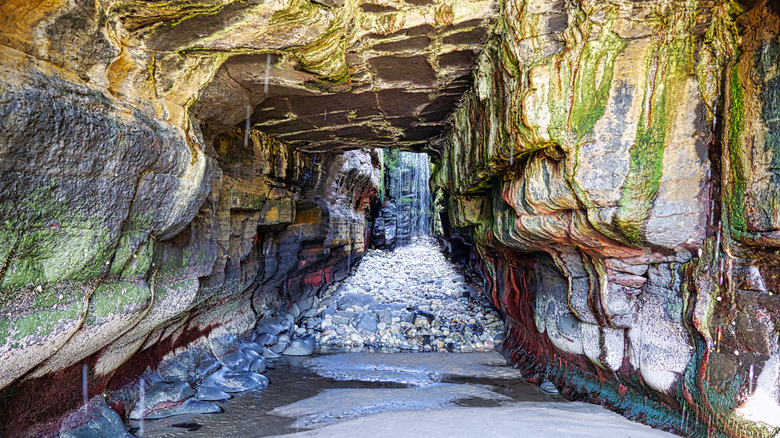
The secret waterfall tucked away among the coastline near Killybegs isn't really all that secret. It's become well known as of late, with its own pin on Google Maps noting it as the "Secret Waterfall." But Largy Waterfall remains a much-overlooked spot in any trip to Ireland and its enchanting north. It can be found just down the road from Slieve League, making it a great destination on your way to or from the towering cliffs of Donegal. Yet, a visit can only happen during low tide, ensuring that the "secret" moniker retains at least some purchase. It's nestled down near the shore within a cave, and during higher tides, the entrance is completely engulfed in water. This makes the entry path into the waterfall's domain a little bit treacherous. Similarly, any visit to the waterfall must be started and ended during low tide, with the best possible visiting schedule coinciding perfectly with the turnover in tidal direction to ensure the longest possible visit.
The waterfall itself is a beautiful sight, found within the cavernous opening shortly down the shore from a private field that visitors will have to navigate (the owner has been accommodating thus far to visitors hoping to catch a glimpse). Respect for the roadway, land, and community is, therefore, a must. But the sight and sound of rushing water in this sheltered space is a must for anyone traveling around Donegal.
Errigal, the tallest peak in Donegal
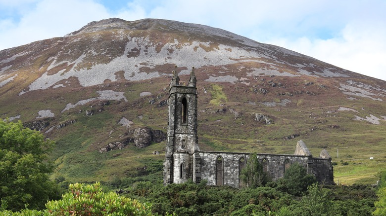
The tallest peak in an Irish county is a highly regarded thing. Whether it's Galtymore in Tipperary or Truskmore in Sligo, getting out in nature and climbing your county's natural summits is something that many Irish people take great pride in. The same can be said for those hailing from Donegal, and Errigal is that height that brings people closer to the land that sustains them.
A hike up Errigal's rise, 2,463 feet above sea level, will take roughly three hours, and the trail runs about three kilometers each way (six kilometers in total, or a little under four miles round trip). At the top, you'll be treated to stunning views in every direction. The mountain is found in Donegal's northwest, and Glenveagh National Park sits in its shadow. Glenveagh Castle and the National Park make up another fantastic reason to make the trip up to the mountain. If you aren't much of a hiker (or want to explore this fantastic ground-level site after summiting the peak in the morning, for instance) exploring the park and castle will give you a phenomenal look into the wind, natural habitat of Ireland's northwest.
Nancy's Barn, Ballyliffin
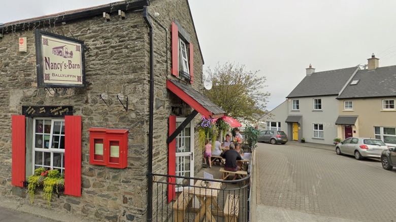
This restaurant isn't very far from Malin Head, and visitors traveling through Ballyliffin on their way to or from the north extent will surely notice the "world famous chowder" signs that adorn the building. The atmosphere in the restaurant acts as the perfect complement to a day on the road exploring. Moreover, the bowl of chowder certainly doesn't disappoint. It's an incredibly good dish and one that a second trip through Donegal might have you planning a return visit to Ballyliffin for the chowder alone.
It's not set in a location that might see a visit if you weren't passing through Ballyliffin already, but adding a stop here or redirecting your route so that you can make time for a hearty meal, especially if you're traveling on a cold or rainy day in the northern reaches of Ireland, will offer a wonderful and authentic Irish experience.
Ballyliffin Golf Club
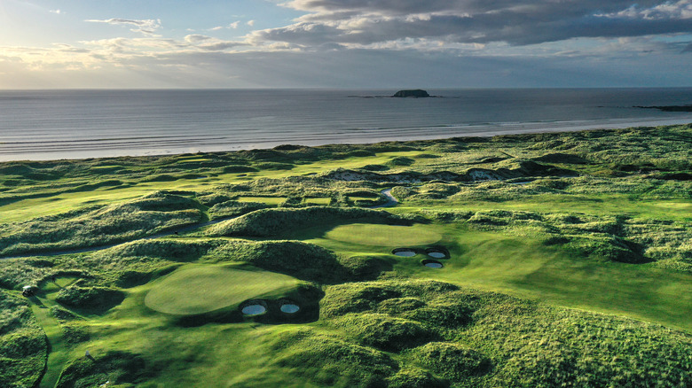
In addition to a stop at Nancy's Barn along the main Ballyliffin thoroughfare, golfers looking to explore the Emerald Isle's many great courses will want to seriously consider a tee time at Ballyliffin Golf Club. The titanic, three-course club (including a 9-hole endeavor) is regarded as one of the best links courses in the entire country — and that's saying something!
The Old Links (par 71, 6,937 yards off blues) and Glashedy Links (par 72, 7,542 yards from blacks) courses are each challenging and immensely rewarding golfing experiences for players hoping to take something of the island back with them. Overlooking Pollan Strand beach, either course provides a wonderful day out on the fairway, set against the majestic sights of the Donegal shoreline. Both links courses have hosted a range of tournaments, including the European Tour 2018 DDF Irish Open (Glashedy), and the European Tour Irish Seniors Open in 2008 (Old Links).
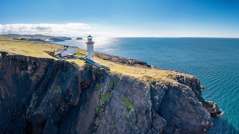
Fanad Lighthouse
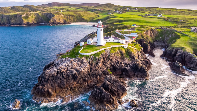
The north — and the entirety of Ireland's lengthy west coast — is dominated by special little nooks and crannies. Often, these fingers jutting out into the ocean are raised on spectacular cliffsides, like the Cliffs of Moher in Clare, Kerry Cliffs or Dunquin in County Kerry, or Donegal's own Sliabh Liag cliffs. Many of these coastal landscapes, shaped inexplicably by the power of the sea, support lighthouses out of necessity to protect sailors and fishing vessels from the dangers presented by these rocky shores. The coastal debris that reaches out into the waters along with heavy currents that swirl near the shoreline make navigation a dangerous endeavor, particularly in the fog or at night. As such, towering lighthouses stand proud along Ireland's shores, including Fanad Lighthouse at the northern tip of the Fanad Peninsula and between Lough Swilly and Mulroy Bay. This was voted as one of the most beautiful lighthouses in the world at one time, and the brilliant white, grey, and red tower isn't the only spectacular sight you'll come across on the way up to this fixture on Donegal's coast. Taking a tour of the lighthouse will provide you with a better look at the history and importance of this installation, making it an even more awe-inspiring visit.
Boyeeghter Strand (Murder Hole Beach)
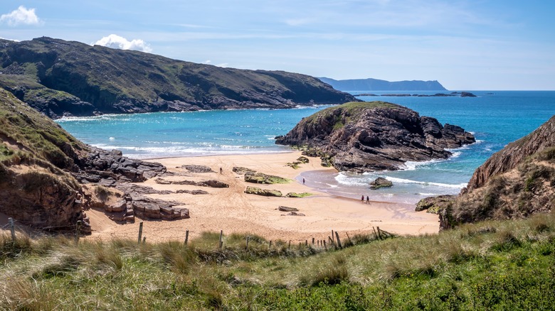
Boyeeghter Strand is better known as Murder Hole Beach (certainly a more interesting name). The beach is cut into two segments during low tide, as the waves recede and expose a sandy gap between the mainland and a large rock formation that rises out of the surf just offshore. Plenty of beaches in Ireland exhibit this sort of behavior, but the glorious sands of Murder Hole Beach are some of the finest.
Up near the tip of a peninsula jutting out above Glenveagh National Park, and one "finger" over from Fanad Lighthouse, the beach is a little out of the way. However, it's a delight to run your toes through the sand at this phenomenal oceanside spot. Care should be taken when considering a dip in the ocean, however. Rip currents here, developed in part due to the rock centrally positioned between the two beach segments, make for dangerous seas, even at the best of times. Even strong swimmers should be careful if they plan to wade out into the surf here. Low tide is the best opportunity for enjoyment on the shoreline, so make sure you check the tides before making the journey up to this part of the county.
Glengesh Pass
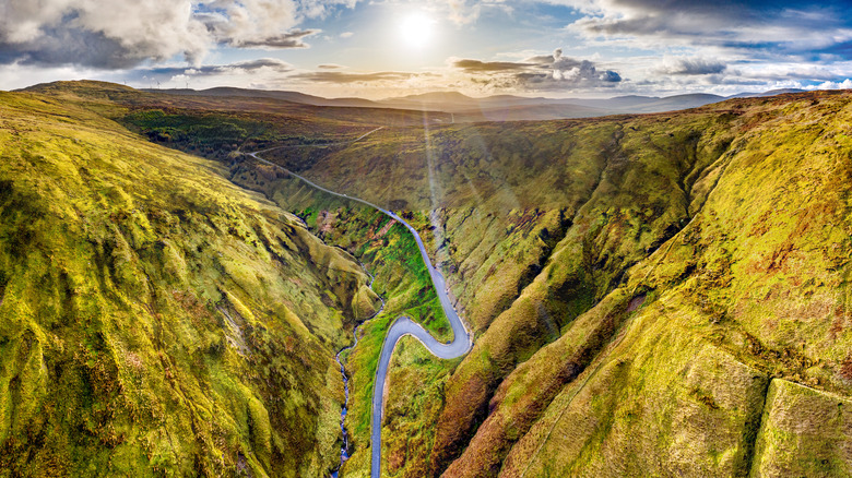
If you're staying in Letterkenny, you're likely to naturally take the Glengesh Pass as you make your way to Sliabh Liag. For others, rerouting your journey through this windy corridor is a welcome change that brings a wonderful, scenic journey into the fold. There are a few stopping points along the way, and it's not uncommon to see plenty of parked cars with visitors milling about and taking in the glorious scenes of remote, rural Ireland. There are plenty of hidden spots in the country that don't require you to get out of your car and explore something on foot. Taking in a mountain drive is one of those special activities that is in constant supply. Whether it's the loop from Westport down to the Killary Fjord in Mayo or the Gap of Dunloe in Kerry, these kinds of mountainous driving are incredibly rewarding. The Glengesh Pass is one of the most dramatic roadways in the country, making for an unforgettable addition as you pass through on your way to or from another excellent destination on your journey.
On your way out of the Republic, stop in Derry, Northern Ireland
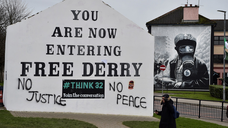
Finally, on your way out of the Republic of Ireland's northernmost county, a stop across the border in Derry is a highly recommended aside. While it's not within the bounds of County Donegal, Derry is a monumental site in Irish history, and was one of (if not the) magnetic epicenters of the Troubles that dominated Irish culture and politics from the 1960s until surprisingly recently (with the signing of the Good Friday Agreement in 1998).
History is truly alive here, and the hum of the city still resonates with the rebellious spirit of both predominantly Catholic Irish nationalists at heart and Protestant loyalists who wanted to retain ties with the United Kingdom. Derry is firmly planted in Northern Ireland, making it a part of the U.K., but it's distinctly its own kind of space. The walled city is one of the most enchanting anywhere in Europe, with its defensive structures built between 1613 and 1618 to protect settlers who had moved from Scotland and England into the area. This makes them somewhat of a contentious monument to history, even today. Perhaps the most awe-inspiring portion of the city can be found just down the hill and west of Derry's walled portion. Free Derry Corner retains the "You Are Now Entering Free Derry" mural and often doubles as an additional political slogan for other piggybacking causes. Around the corner, there are other powerful murals that depict the battles taking place in Derry's contested streets.