Where To Visit The Most Historic Landmarks In The Northwest
The American Northwest is a blend of breathtaking scenery with echoes of the past. Its coastlines, valleys, and peaks are natural wonders, where Native American legends are etched into the walls, pioneers braved the unknown, and earth-shattering events shaped mountains. There's enough for a lifetime of discovery, from Oregon's iconic ending and Washington's hidden enchantments to Montana's solemn battlegrounds and worn roads of Wyoming.
These natural landmarks resonate with profound cultural, spiritual, or religious significance for indigenous people. While some were beacons, guiding the early pioneers and molding the trajectory of Western exploration. Yet, they all stand as emblems of pride, identity, or introspection. While some epitomize the indomitable American spirit, others honor the memories of the original inhabitants who cherished the land long before settlers arrived. Some do both. So, lace up your hiking boots, open your history books, and let curiosity take the lead as we journey through the most iconic landmarks of the Northwest.
The South Pass
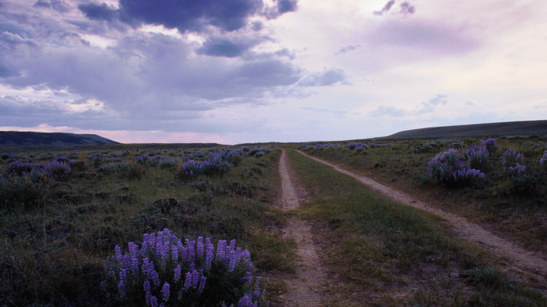
Wyoming's South Pass paved the way for American expansion. In 1805, Lewis and Clark's Corps of Discovery almost froze and starved, trying to cross the Rocky Mountains. Manifest Destiny underlined migration, settlement, and military leverage. People were driven west towards Oregon and California by the allure of free land, the glimmer of gold, and the pursuit of religious freedom (and missionary work).
The Rocky Mountains were a hindrance to westward expansion. Stretching over 3,000 miles from Alaska to New Mexico, the Rockies are a maze of mountain ranges, valleys, and rugged terrain. The weather could change from dangerously cold to severe thunderstorms, and the settlers encroaching upon Native lands were not always welcomed. Thus, travel, trade, and communication weren't easy — near impossible for families.
It all changed with the 20-mile-wide South Pass — a gap through the dangerous Rockies — making travel quicker and safer. Known by Native Americans for centuries, the South Pass was uncovered in 1824 by legendary (anyone who fights a bear and lives is legendary) frontiersman Jedediah Strong Smith with help from Crow natives. In 1843, a massive caravan of 120 wagons, 1,000 people, and even more livestock crossed the South Pass, opening the way for up to 500,000 settlers. Today, South Pass is a U.S. National Historic Landmark. Visitors can see the deep trails etched into the pass, enduring symbols of a bygone era, a road carved by emigrants and their wagon wheels as they sought greener pastures.
Little Bighorn Battlefield
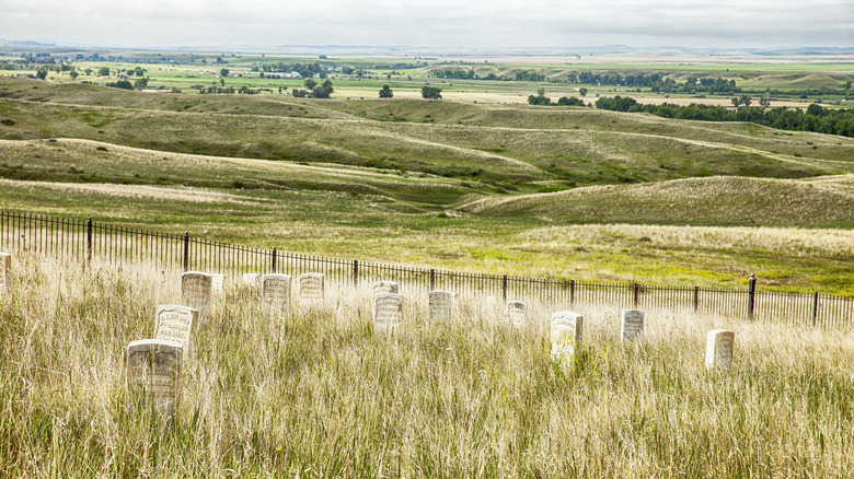
The Little Bighorn Battlefield in Montana marks one of the last armed efforts of the Northern Plains Indians to preserve their ancestral way of life. It is here, in 1876, that the Battle of Little Bighorn, often referred to as "Custer's Last Stand", took place. This battle saw the combined forces of the Lakota, Northern Cheyenne, and Arapaho tribes clash with the 7th Regiment of the U.S. Cavalry, led by Lieutenant Colonel George Armstrong Custer.
The coming together of these tribes represented a significant moment of unity against a common threat — U.S. military forces, forced displacement, and theft of their traditional lands. The U.S. government's westward expansion ambitions, breach of previous treaties, and the discovery of gold in places like the Black Hills led to conflict.
The total defeat of Custer and his troops symbolized Native American resistance against U.S. expansionist policies and military intervention. For the indigenous tribes, this battlefield is a place of remembrance and cultural and spiritual significance. While the grounds represent a defeat for Custer, the field also commemorates the resilience, unity, and defense of the traditions and territories against overwhelming odds for the indigenous community.
Today's visitors to the Little Bighorn Battlefield will find it both haunting and educational. Scattered markers point where soldiers and Native warriors fell, a stark visual representation of the battle's intensity. The site is well-preserved. The surrounding landscape, rolling hills, and the Big Sky vistas of Montana add to the site's contemplative ambiance, making it a powerful destination for understanding a pivotal moment in American history.
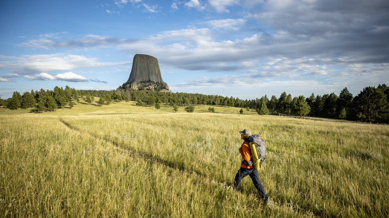
Devils Tower
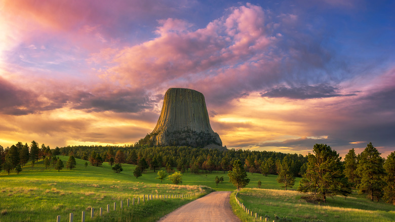
Devils Tower is a beacon in northeastern Wyoming, intertwining Native American heritage with pivotal moments in American history. According to the National Park Service, it was, and remains, a sacred site for over 20 Native American tribes. Many bears made the rock formation their home, so several legends associate it with bears. Before it was ever Devils Tower, it was Bear's Tipi or Bear Lodge. A translation error transformed "Bad God's Tower" into "Devils Tower," a name some Native American tribes consider offensive and have sought to change.
In the late 19th century, as westward expansion surged and settlers moved across the vast landscapes of the American West, the tower emerged as a recognizable landmark, signaling the mysteries and challenges of the uncharted territories. Its looming presence bore silent witness to the tides of pioneers, gold rush seekers, and the ebb and flow of Native American life as tribes grappled with the implications of a rapidly changing world.
In 1906, President Theodore Roosevelt, a strong advocate for conservation, designated Devils Tower as America's first national monument. Although he likely never visited himself, the president believed in preserving America's natural and cultural wonders for future generations. Thus, he signed The Antiquities Act, which gave the president the authority to protect "historic landmarks, historic and prehistoric structures, and other objects of historic or scientific interest." Devils Tower is a powerful reminder of how the natural world, indigenous narratives, and broader American history are linked.
Going-to-the-Sun Road
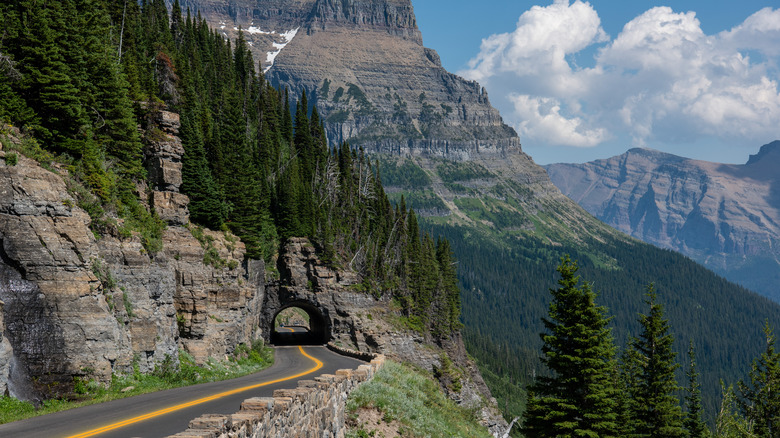
Going-to-the-Sun Road in Montana's Glacier National Park is one of America's most iconic engineering feats and scenic byways. Constructed between 1921 and 1932, this 50-mile stretch symbolizes early 20th-century achievements in civil engineering and represents the national movement to make the country's natural wonders accessible to the public. Its name, derived from local Native American legends, came from nearby Going-To-The-Sun Mountain. Although it was first planned as the "Transmountain Highway."
Its construction was a testament to human determination, as workers faced challenging topography, unpredictable weather, and the mandate to minimize environmental impact. Minimum equipment was used — there were even limitations on dynamite. The result was a roadway that gracefully integrates with its surroundings, offering incredible sceneries and access to key areas of the park.
For visitors, Going-to-the-Sun Road is a journey through time and nature. Traveling its span, one can spot dense cedar forests to alpine tundras. Highlights include the pristine Lake McDonald, the Weeping Wall with cascading waterfalls, and the lofty Logan Pass with sweeping views of the park's vast glaciers and valleys. Safe pullouts are available throughout the drive so drivers can stop, take in the views, and learn about the history of the road and park. Whether spotting diverse wildlife, soaking in the mesmerizing views, or simply enjoying the drive, Going-to-the-Sun Road offers an immersive experience into America's engineering and park legacy.
First Peoples Buffalo Jump State Park
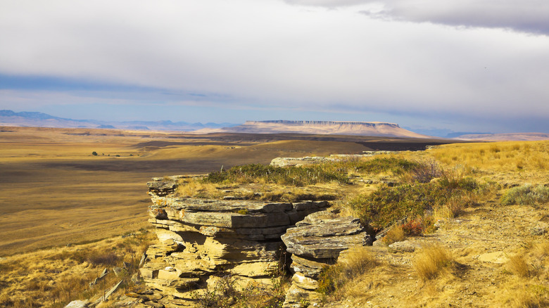
First Peoples Buffalo Jump State Park in Montana is perhaps the largest and one of the oldest Native American heritage sites in North America. This archeological landmark represents the deep-rooted relationship between the indigenous tribes of the Northern Plains and the American bison, which was essential to their survival and cultural practices.
A sandstone cliff stretching a mile long with a drop of 50 feet, First Peoples Buffalo Jump was used by tribes from what is now Northwestern Montana, Wyoming, and Idaho, including the Blackfoot Confederacy, Crow, Gros Ventre, and Assiniboine nations, for buffalo jump hunting. This collective hunting technique involved driving bison, sometimes in groups of hundreds, over cliffs for food, clothing, and tools.
According to Central Montana, indigenous tribes used this Buffalo Jump for over two centuries. The Blackfeet referred to buffalo jumps as "pishkun," meaning "deep blood kettle," and the site is still known today as Ulm Pishkun. Even today, one can see traces of drive lines atop the cliff, and 18 feet of compacted buffalo remains lie beneath it. First Peoples Buffalo Jump was listed on the National Register of Historic Places in 1974 and made a National Historic Landmark in 2015. The park has an education center highlighting buffalo jumps and related cultural practices. Walking trails have breathtaking views of the plains and panoramic vistas of the Missouri River Valley, the Rocky Mountain Front, and several mountain ranges.
Hell's Canyon
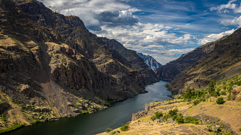
Divided between the borders of Oregon, Washington, and Idaho, Hell's Canyon represents nature's raw power and the passage of time. It emerged from volcanic activity in the Pacific 300 million years ago, was forced to North America by tectonic shifts, and was sculpted by the persistent erosion from the Snake River. Hell's Canyon has depths of nearly 8,000 feet, which makes it the deepest river gorge in North America. Even 2,000 feet deeper than the Grand Canyon.
Trekking Hells Canyon isn't easy, which possibly gave it its name. When the Lewis and Clark expedition reached the canyon, they took one look and promptly turned around. Today, no roads cross the canyon, but the Hells Canyon Scenic Byway, one of Idaho's 31 scenic byways, wraps around the canyon's edge.
The canyon's walls are a canvas of human history. The Nez Perce made the region their home for thousands of years. Their legacy is etched into the canyon's walls with carvings and pictographs. After treaty breaches that originally allocated 7.5 million acres to the tribe, the U.S. Government engaged in armed conflict with the Nez Perce and forced them to relocate. In another dark chapter in 1887, Chinese miners seeking fortune in the canyon were murdered by white thieves. In 2012, a memorial was erected there in Chinese, English, and Nez Perce. These events are a reminder that despite its natural splendor, a shadow of injustice looms over Hells Canyon.
Craters of the Moon National Monument and Preserve
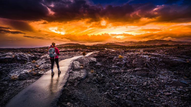
Idaho's Craters of the Moon National Monument and Preserve encapsulates the geological history of America. Formed between 15,000 and 20,000 years ago, Craters of the Moon showcases volcanic features, expansive lava fields, pristine cinder cones, and deep rift cracks. These formations present valuable insights into volcanic processes, the dynamics of the Earth's crust, and the forces that have shaped our planet's surface.
The park's pristine landscape is a natural laboratory for geologists to study and understand volcanic eruptions and their aftermath. The increased recognition of its geological and scientific merits led President Calvin Coolidge to designate it as a national monument in 1924. President Clinton extended the park's boundaries in 2000 to over 1,000 square miles.
This landscape was thought to resemble the lunar surface. Albeit before humanity ever set foot on the moon. Hence the name "Craters of the Moon." During the height of the space race, NASA used Craters of the Moon as a training location for Apollo 11 to familiarize them with volcanic geology and to prepare them for the unknown terrain they might encounter on the moon. However, today, we know our moon does not in fact mirror the Idaho countryside.
Mount St. Helens
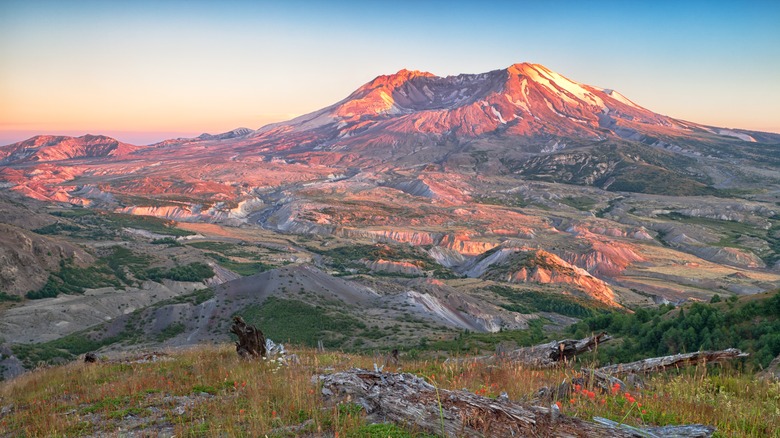
Mount St. Helens in Washington is an iconic landmark in American history, primarily due to its explosive eruption on May 18, 1980. This eruption, the most catastrophic in U.S. history, impacted the surrounding landscape, ecology, and communities. Sadly, the eruption took 57 lives, including geologist David A. Johnston, whose timely alerts undoubtedly saved many, and photographer Robert Landsberg. When Landsberg realized he couldn't escape the approaching ash cloud, he heroically captured the eruption's fury until the very end.
The mountain had been dormant for over a century before it roared back to life in the spring of 1980. The eruption expelled ash that traveled more than 22,000 miles — as far as the central U.S., causing widespread darkness in cities such as Spokane. The surrounding area met utter destruction. Forests were erased, rivers became choked with volcanic material, and the landscape transformed, giving rise to 150 new lakes and ponds.
Beyond the immediate destruction, the event spurred scientific research. It triggered a reevaluation of volcanic monitoring and disaster readiness. In 1982, Congress designated Mount St. Helens as a national monument, making the mountain a leading global site for volcanology studies.
The Enchantments
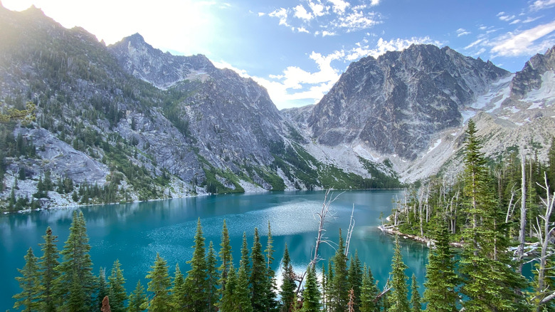
Hidden away in Washington's Cascade Range, within the Alpine Lakes Wilderness, The Enchantments beckon. Along its trails, the radiant waters of Colchuck Lake come into view, mirroring the majestic silhouettes of Dragontail and Colchuck Peaks. While the trek is challenging, the rewards are turquoise lakes, lush meadows, and unparalleled views. Such is the allure of this destination that a lottery system determines the fortunate few who receive camping permits each year.
According to the Seattle Met, although known to indigenous tribes for generations, the region was largely uncharted to settlers until the early twentieth century. It was then that Albert Hale Sylvester, a topographer with the United States Geological Survey (USGS), extensively surveyed the area. Struck by its beauty, Sylvester named it after commenting it was "an enchanting scene."
The Enchantments region is under several protections to preserve its untouched beauty. The 1964 Wilderness Act ensures the area remains natural – free from commercial enterprises, roads, and motorized equipment. In 1976, President Gerald Ford enacted the Alpine Lakes Area Management Act, designating a section of the region as a wilderness. As defined by the U.S. Department of Agriculture, this status recognizes the area's significance for its historical, scientific, educational, geological, and ecological attributes. Reflecting on the beauty, President Ford aptly remarked upon signing, "Anywhere so beautiful should be preserved."
Cape Disappointment
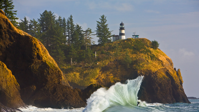
Cape Disappointment, located at the confluence of the Columbia River and the Pacific Ocean in Washington, is not disappointing at all. Its name stems from the disappointment of Captain John Meares. In 1788, the English fur trader and explorer failed to cross the river's shoal, leading him to name the cape to reflect his thwarted efforts. However, the cape also holds significant importance in the chronicles of American exploration.
On November 18, 1805, the Lewis and Clark Expedition group journeyed southwest along Baker Bay near the coast. After hunting down their first-ever California condor, described as a "very large turkey," they climbed a narrow peninsula, the edge of Cape Disappointment, where they set eyes on the Pacific for the first time.
Although some thought Lewis and Clark named the cape in disappointment after not sighting any vessels, they were elated, likely just taking it all in. Clark wrote his men were "beholding with [astonishment] the high waves dashing against the rocks and this [immense] ocean." For Lewis and Clark, reaching this point marked the culmination of their two-year and four-month westward journey and realizing their mission's primary goal, as commissioned by President Thomas Jefferson — finding a navigable route to the Pacific Ocean.
The Lower Klamath National Wildlife Refuge
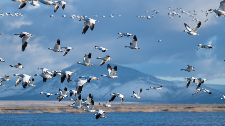
The Lower Klamath National Wildlife Refuge is the first waterfowl refuge in the United States and a century-long testament to conservation. Situated between Oregon and California, its diverse landscape spans over 50,092 acres. It contains shallow marshes, open waters, and grassy landscapes for migrating waterfowl to feed, nest, and raise their young. Once a vast expanse, the basin's wetlands had been significantly reduced due to agricultural development, prompting the need for a protected sanctuary.
In 1908, President Theodore Roosevelt was instrumental in establishing the refuge. Under his leadership, the refuge ensured that the diverse bird species of the Pacific Flyway (one of the major bird migration routes in North America) had a haven during their migratory journeys and protected it from potential development or other activities that could harm the ecosystem. Today, the Lower Klamath National Wildlife Refuge is a vibrant ecosystem teeming with life. Visitors can see the spectacular sight of vast flocks of waterfowl — up to 1.8 million birds annually, including around 30,000 tundra swans and 500 bald eagles in winter.
The Vista House at Crown Point
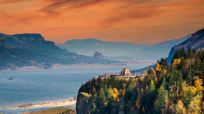
The Vista House at Crown Point, perched atop the Columbia River Gorge in Oregon, is a monument to the early 20th-century spirit of the Pacific Northwest. Constructed between 1916 and 1918 as a rest stop and observatory for travelers on the Historic Columbia River Highway, the Vista House was envisioned by Samuel Lancaster, the highway's chief engineer, to serve travelers of "America's greatest highway."
Designed by Edgar M. Lazarus, the octagonal stone structure showcases German Art Nouveau architecture and was a tribute to early pioneers. Inside, a museum offers visitors insights into the history of the Vista House, the development and significance of the Historic Columbia River Highway, and the natural wonders of the Columbia Gorge. From the observatory, one can see the expansive Columbia River winding through the gorge, flanked by towering cliffs and lush, forested hillsides. Depending on the season, the river might be calm and reflective or covered with whitecaps. On clear days, the surrounding peaks and mountains provide a majestic backdrop. The play of light, especially during sunrise or sunset, paints the gorge in a myriad of colors, from deep blues and greens to fiery oranges and purples.